
About 6 weeks ago, I started homeschooling Spencer. I printed out the state standards for all the subjects so I could make sure I covered what the state thinks is important just in case he needs (or would like) to return to public school at any point...
I could not initially find a middle school geography social studies curriculum that rocked my socks...I knew geography had to be more interesting and exciting than the book we were using.. So....while I was researching and ordering something else, I started using internet and library resources and put together a little unit/lesson plan of sorts. Then, Spencer took all the individual things he made and made them into a flipbook. I will include some of the resources and some pics.....
First, we went to the library and checked out all the books we could find on Tennessee in the juvenile section. He started looking/reading through different sections to research the info he needed. One of the main websites we used to glean info. was http://www.tnhistoryforkids.org/geography/m_1
Day 1: Identify the 3 main divisions of TN. Look at a map of TN and draw a basic outline. Draw dividing lines for the 3 divisions and label: west, middle, and east. Cut out the outline and trace another outline on cardstock so you can make a flip book. Staple the one you draw on to the copy at the top of each division. Cut where the division lines are. Begin looking for natural resources , industries etc. found in each division looking online and in books. Write those down or type them in a "word" document under West, Middle, or East.

Day 2: Look for pictures of each of the resources you listed yesterday. Use "Google" images. Copy them into a "Word" document and print them out. Paste them under the section in which they are found (West, Middle, East) This picture is taken when you lift the 3 grand division flaps.

Day 3: Print out a map of the counties in TN (or any state) for free at http://www.waterproofpaper.com/printable-maps/ Print out a geological map at http://www.tn.gov/environment/tdg/images/geolog_l.jpg
By printing out the 2nd map, the students are able to see how the geology of TN determines the 6 physical regions. Then, have the students draw dividing lines, color, and create a map key labeling each physical region.

Day 4: Make a flip book with 6 flaps-one for each physical region. To make this flip book, use 3 pieces of paper and scoot each one up and inch from each other. Then, fold the whole thing in half. Label each tab with one of the 6 physical regions. Go to the http://www.tnhistoryforkids.org/geography/m_1 website and research at least 2 facts to write for each region. Write those in the flip book. Watch the short video on that website at this link where the guy takes you on a journey to visit each of the 6 regions. http://www.tnhistoryforkids.org/videos It is called, "Trek across Tennessee."

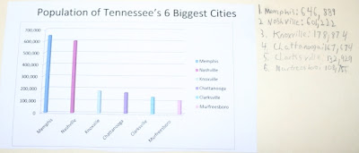
Day 5: Research the 5 largest (population-wise) in Tennessee. Spencer found this site helpful: http://www.citypopulation.de/USA-Tennessee.html He actually included the top 6 on his. Then, I coached him on how to use "Microsoft Word" to make a bar graph. You can go into "Word", click blank document, click "Insert" tab at the top, then click "column" in the pop up box and hit ok. "Excel will automatically pop up and you just enter the data. Voila! This was really cool!
1 c. salt
1/2 - 2/3 c. water
I would lean more on the side of 1/2 cup of water though b/c 2/3 was too much and he had to add more flour.
The best way to do this is to cut out a piece of cardboard in the shape of TN and then mold the playdough inside your boundaries.
Day 7: Paint the 6 regions on the salt map using the same colors used on the paper from Day 3.
 Day 8: Label the 3 grand divisions, make a title for the map, and create a map key using push pins and writing the corresponding number on the key. It was at this step that I instructed Spencer to take a picture of the salt map and I coached him how to upload the picture to a website and order a print so he could include it in his flipbook. (Glad I did b/c our dog thought the Unaka Mtns. looked tasty, so she took a little bite when we laid it on the floor and walked off).
Day 9: Visit the local chamber of commerce or visitor's center (We have a brand new one in our area). Look at interactive exhibits and grab booklets and maps that might be helpful for the continuation of the project.
Day 10: Print out a rivers map for TN here. http://geology.com/lakes-rivers-water/tennessee.shtml Print out another blank county map and have the student draw the 3 main rivers in TN in their correct location. They are: The Mississippi, The Tennessee, and The Cumberland Rivers.

Day 11: Make a river flipbook with 3 flaps. Label each flap with one of the major river systems in TN. Underneath each flap, write at least two interesting facts using online resources or library books.

 Day 12: Assemble all the info. and flipbooks to be included in one big foldable (using two file folders). Cut out pictures from the pamphlets from the visitors center that represent TN and glue pictures on to the cover.
I modeled how to give a presentation with the foldable to "teach" others about TN. Then, he practiced with me, later with his gramma when she came over, and again with his dad this weekend. He learned A LOT about Tennessee.

Just in case you're interested, these are the standards covered for Social Studies 7th Grade:
7.2.spi5 select the major resources, industrial, and agricultural products for the three grand divisions of TN
7.2.tpi7 know the major resources, industrial and agricultural projects from TN
7.3.05 understand that common physical characteristics create regions.
7.3.spi.3 identify the major river systems of Tennessee
7.3.spi.5 select the natural resources found in the 3 grand divisions of TN (coal, copper, timber, plants, animals)
7.3.spi.7 compare the five largest cities of Tennessee using a bar graph
7.3.spi.12 identify the six physical regions of TN (Unaka Mtns,Valley and Ridge, Cumberland Plateau, Highland Rim, Central Basin, Gulf Coastal Plains)
7.8.tpi.8 construct a salt map illustrating the six regions in TN
There are other language, reading, and technology standards covered but I won't go into all that. Whew! I was so proud of Spencer when he finished. It was a lot of work, but it made learning authentic!
Now, we're on to learn about Africa! :)
With Much Love,

I could not initially find a middle school geography social studies curriculum that rocked my socks...I knew geography had to be more interesting and exciting than the book we were using.. So....while I was researching and ordering something else, I started using internet and library resources and put together a little unit/lesson plan of sorts. Then, Spencer took all the individual things he made and made them into a flipbook. I will include some of the resources and some pics.....
First, we went to the library and checked out all the books we could find on Tennessee in the juvenile section. He started looking/reading through different sections to research the info he needed. One of the main websites we used to glean info. was http://www.tnhistoryforkids.org/geography/m_1
Day 1: Identify the 3 main divisions of TN. Look at a map of TN and draw a basic outline. Draw dividing lines for the 3 divisions and label: west, middle, and east. Cut out the outline and trace another outline on cardstock so you can make a flip book. Staple the one you draw on to the copy at the top of each division. Cut where the division lines are. Begin looking for natural resources , industries etc. found in each division looking online and in books. Write those down or type them in a "word" document under West, Middle, or East.

Day 2: Look for pictures of each of the resources you listed yesterday. Use "Google" images. Copy them into a "Word" document and print them out. Paste them under the section in which they are found (West, Middle, East) This picture is taken when you lift the 3 grand division flaps.

Day 3: Print out a map of the counties in TN (or any state) for free at http://www.waterproofpaper.com/printable-maps/ Print out a geological map at http://www.tn.gov/environment/tdg/images/geolog_l.jpg
By printing out the 2nd map, the students are able to see how the geology of TN determines the 6 physical regions. Then, have the students draw dividing lines, color, and create a map key labeling each physical region.

Day 4: Make a flip book with 6 flaps-one for each physical region. To make this flip book, use 3 pieces of paper and scoot each one up and inch from each other. Then, fold the whole thing in half. Label each tab with one of the 6 physical regions. Go to the http://www.tnhistoryforkids.org/geography/m_1 website and research at least 2 facts to write for each region. Write those in the flip book. Watch the short video on that website at this link where the guy takes you on a journey to visit each of the 6 regions. http://www.tnhistoryforkids.org/videos It is called, "Trek across Tennessee."

Day 5: Research the 5 largest (population-wise) in Tennessee. Spencer found this site helpful: http://www.citypopulation.de/USA-Tennessee.html He actually included the top 6 on his. Then, I coached him on how to use "Microsoft Word" to make a bar graph. You can go into "Word", click blank document, click "Insert" tab at the top, then click "column" in the pop up box and hit ok. "Excel will automatically pop up and you just enter the data. Voila! This was really cool!

Day 6: Make a salt map of the six physical regions. I found a great website that explained how to do it here: http://shoutingforha.blogspot.com/2011/04/tennessee-salt-map.html Bascially, to make the dough, you need
1 c. flour1 c. salt
1/2 - 2/3 c. water
I would lean more on the side of 1/2 cup of water though b/c 2/3 was too much and he had to add more flour.
The best way to do this is to cut out a piece of cardboard in the shape of TN and then mold the playdough inside your boundaries.
Day 7: Paint the 6 regions on the salt map using the same colors used on the paper from Day 3.

Day 9: Visit the local chamber of commerce or visitor's center (We have a brand new one in our area). Look at interactive exhibits and grab booklets and maps that might be helpful for the continuation of the project.
Day 10: Print out a rivers map for TN here. http://geology.com/lakes-rivers-water/tennessee.shtml Print out another blank county map and have the student draw the 3 main rivers in TN in their correct location. They are: The Mississippi, The Tennessee, and The Cumberland Rivers.

Day 11: Make a river flipbook with 3 flaps. Label each flap with one of the major river systems in TN. Underneath each flap, write at least two interesting facts using online resources or library books.


I modeled how to give a presentation with the foldable to "teach" others about TN. Then, he practiced with me, later with his gramma when she came over, and again with his dad this weekend. He learned A LOT about Tennessee.

Just in case you're interested, these are the standards covered for Social Studies 7th Grade:
7.2.spi5 select the major resources, industrial, and agricultural products for the three grand divisions of TN
7.2.tpi7 know the major resources, industrial and agricultural projects from TN
7.3.05 understand that common physical characteristics create regions.
7.3.spi.3 identify the major river systems of Tennessee
7.3.spi.5 select the natural resources found in the 3 grand divisions of TN (coal, copper, timber, plants, animals)
7.3.spi.7 compare the five largest cities of Tennessee using a bar graph
7.3.spi.12 identify the six physical regions of TN (Unaka Mtns,Valley and Ridge, Cumberland Plateau, Highland Rim, Central Basin, Gulf Coastal Plains)
7.8.tpi.8 construct a salt map illustrating the six regions in TN
There are other language, reading, and technology standards covered but I won't go into all that. Whew! I was so proud of Spencer when he finished. It was a lot of work, but it made learning authentic!
Now, we're on to learn about Africa! :)
With Much Love,

No comments:
Post a Comment